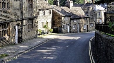
Glossop & Old Glossop

Like Hope, Hathersage and Chapel-en-le-Frith, Glossop was once a vast parish of over 50,000 acres, subsequently subdivided, covering the hills of the western Dark Peak. In 1086 it was part of an even larger entity, the lordship of Longendale, held directly by the king, and it remained as such except for a brief period under Henry I when it was granted to William Peveril. After the Anarchy however, Henry II gave it to the Cistercian Abbey of Basingwerk, Flints (now Clwyd) and they held it until the Dissolution. As a result, Henry VIII granted it to Francis Talbot, 5th Earl of Shrewsbury and it remained largely with his descendants, the Talbots and the FitzAlan-Howards, Dukes of Norfolk, until the twentieth century. Old Glossop sits on a south facing hillside, and originated in the medieval period. The modern town, initially Howard Town, later New Glossop and now just Glossop, was created around cotton mills in the early 19th century through the encouragement of the FitzAlan-Howards (whose coat-of-arms can be seen all over the place) and lies further down, occupying the valley. The name, according to modern reference books, derives from the Anglo-Saxon hop(e) (= valley), suffixed to the notional Saxon name of ‘Glott’ (in the genitive, hence an additional ‘s’), thus ‘Glott’s valley’. However, these references invariably prefix the name with an asterisk, which means it has been deduced by academics from the name’s earliest forms but is unattested by any known personage bearing it. Bearing in mind that the area probably remained under British control until near the end of the seventh century, one might propose a British origin for the first element, like Glôg (= a rock or knoll, appropriate enough hereabouts) or the well- attested British personal name Glywys, with the Saxon suffix added. Such hybrid place names are not uncommon, especially in the North and West and more are being admitted as research is re-defined. Such arcana did not affect our visit on a blazing hot day. Old Glossop is a total delight, and once was centered on the hall, latterly a vast, rather unlovely mansion, demolished by the Council in 1959 (see Country Images May 2018). This lay quite close to the church of All Saints, with a fine park rolling down the hillside. The church itself is an ancient one, and quite substantial, but has suffered numerous rebuildings – no less than five since the beginning of the 19th century, leaving little of the original 12th century church. We actually began beside the stump of the medieval churchyard cross, rather neglected looking, on the south side, by walking up from the church past the former church primary school of 1854 by Matthew Ellison Hadfield (1812-1885), a Glossop man, son of the Dukes’ local agent, Joseph, who, through the patronage of the Howards rose to eminence as an architect here and then in Sheffield as Weightman & Hadfield. He designed much of the new town of Glossop. The school is remarkably substantial, and was converted into several spacious houses three years ago, winning an award. We pressed on past up to the upper road, Church Lane continuing NW until we reached ‘the opposition,’ as one elderly local called it, the splendid late Regency Catholic church (also dedicated to All Saints) by M. E. Hadfield of 1836, although it looks almost earlier, with its neat classical villa of a presbytery beside it. It was the private chapel of the (staunchly) Catholic Dukes of Norfolk until 1925, despite the hall also having had an attached chapel. We then pressed on along Church Terrace until we reached the main (Woodhead) road, where we turned left down the hill into Glossop proper. Woodhead Road morphs into Norfolk Street, and for half a mile one passes through a leafy suburb with houses either side ranging from late Victorian to inter-war. Further down, things change: opposite the corner of Kent Road is a pair of stone built houses, very pretty, in an unexpected cottage orné style, followed by a substantial mid-Victorian terrace, with further terraces beyond on both sides. This continues for another country half-mile until suddenly the descent steepens and the road widens. On the right is the very striking Manchester, Sheffield & Lincolnshire Railway’s classical station of 1847 (by the omnipresent Hadfield, naturellement). The noble lion crest of the Howards atop the parapet attests to the fact that the 13th Duke personally paid for the one mile branch line from Dinting that terminates at the rather grand station itself. The line (later the Great Central, then 1923-1948, the LNER) is today still operating and long electrified. Opposite the station a very tall sub-Jacobean Conservative club of 1909 with a first floor angle gallery upheld by a stumpy fat column with stiff leaf capital. Further down, on the corner of High Street, we found the early Victorian Norfolk Arms Hotel, very welcoming, where we paused for much needed sustenance. This, essentially, is the grandly planned centre of Howard Town, later (New) Glossop. We proceeded along Henry Street to Norfolk Square behind the pub, where Tesco have tactfully adapted the station’s good shed, and passed, on our right, an Italianate building, now shops, and a hidden Masonic Hall, its modest entrance amidst a stone residential terrace looking almost furtive in its discretion but, from the notices advertising the availability of a large hall for weddings, funerals and bah-mitzvahs (as it were), we deduced that behind lay an edifice of noble proportions, invisible to us. Opposite lay sloping Norfolk Square itself bosky and with elegant buildings in the usual honey-coloured Dark Peak millstone grit on all sides. The NE corner is host to a tall Jacobean Liberal Club of 1914 by Paul Ogden, with blue plaque honouring Hon. Mrs. Mary Partington MBE a philanthropic ex-Mayor of the town and daughter-in-law of the largest employer in the Borough, Edward, 1st Lord Doverdale). Beside it is a splendidly Belle Epoque war memorial in bronze with winged victory (by Vernon March of Hadfield’s old practice)


