Walk Derbyshire – Matlock to Bonsall
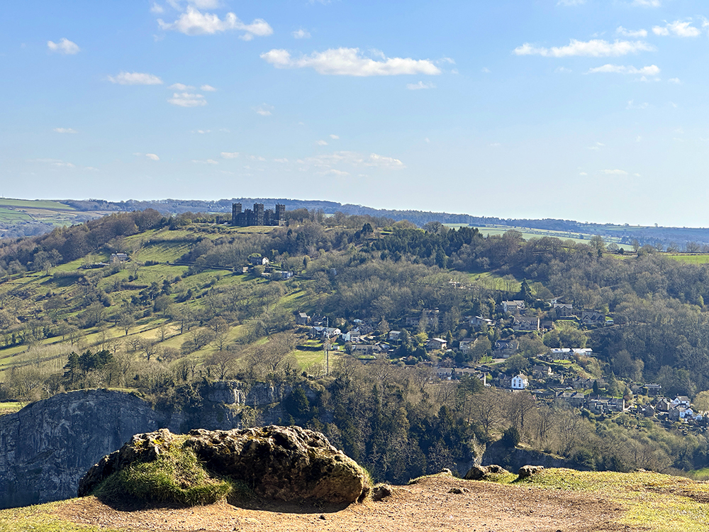
This walk takes in views over Matlock and Bonsall, winding country paths, a quarry, bluebell woodland and farms. It is a little undulated but quite an easy walk with plenty of places to stop along the way and rest if you need to. There were sheep expecting their beautiful babies so hopefully you will be able to spend some time watching the lambs playing if you do this walk this month. PLEASE KEEP ALL DOGS ON LEADS AS IT’S LAMBING TIME!! We would recommend walking boots or good sturdy trainers at least. This walk starts high up over the back end of Matlock after you pass Sainsbury’s. We wind up the hill to find our parking space on Salters Lane which can be a little limited but you should find parking along the lane. Save this walk for a none windy day as you do end up over a high point near Tinker’s Shaft and we don’t want to be responsible for any dogs or humans which may end up flying high! Also, it is worth noting that along the way there is a stunning viewing point which will lend itself to a picnic or just a blanket to sit and enjoy the views. If you would like to do this walk this month then the bluebells should be out in the woods too. There is an opportunity to head into Bonsall during the walk to find a little pub for a swift half or, after the walk. You are only a couple of minutes from Matlock which has many bars and lovely cafes. THE WALK :: THE WALK :: THE WALK :: We park on Salters Lane and head straight up the farm track in front of you where you will come to a galvanised gate with a stile in front of you. Hop over there and follow the footpath. Here you will come to a gate into a disused quarry. When we have been here in the past we have had a little walk down here as a lot of people like to climb in the quarry, so it was good to sit and watch the climbers but be careful – especially with young children. If you don’t wish to have a look at the quarry we turn left over the stile before the quarry gate. Follow the zig zag path all the way through the trees, you will come out into a clearing where you will see two paths. Don’t take the right path but take the left straight down onto the main path at the bottom. We took the right path as it genuinely looks like a footpath and got stuck!///coolest.critic.ratty You should now see a sign saying Heights of Abraham in front of you – hurrah you have gone the right way! When you come to the two yellow footpath posts we are now going to go left. Here are the guaranteed amazing views (unless you decided to come in thick fog) and you can see Riber Castle and Crich stand. This is a beautiful picnic spot – please enjoy and just sit. Moments like this make us happy we live so near to such beauty. We would love to see any photo’s you may take from this point. There is also Tinkers shaft here with lots of history about the mine below on information boards.///chugging.overnight.arrived After you have had a little rest, we head back onto the path and you will see some waste bins in front of you – the footpath heads to the right hand side here. You will head past a couple of signs which say ‘return route’ this is for people visiting Heights of Abraham visitors centre. Follow the path straight ahead and you will see a yellow footpath marker again and we head to the right. Before you get to the cattle grid we go right. Head through the gate into the woodland. Hopefully the bluebells will all be out when you are here. Follow the path all the way through the woodland. When we come out of the woods we head right and go through the large farmer gate. No matter how dry it has been this part through the gateway always seems to be a little muddy. Think of the puddle scene in the Vicar of Dibley!!///resonates.with.refuse Here we head straight along the track in front of you. You will see a little barn in front and a big tree, we head right over the style into the field. When you have followed the path you will come to a bar gate with a stile. We head now on the left path down the field. Head through the trees and to the right and, you will see a new galvanised farm gate where we squeeze through the gap. This is now your chance to head left into Bonsall for a drinky or just carry on up to the right. You will come now to a point where you can go left or right, we are heading straight up to the right.///explain.ferried.galleries We headed onto the top right path where you will come to a closed gate and head right over the stile. Come onto the farmers track and head onto the stone cut through with a white arrow on a yellow post. Here you come out onto a ploughed field but there is a footpath here so go straight through and slowly head down to the left where you will see your car parked! Parking: Roadside parking where Salters Lane turns into Nailor Lane (///swanky.wing.consonant) Pubs: In Matlock there’s plenty to choose from. The Tipsy Toad is a particular favourite of mine. Distance: Long 2.5 miles and approximately 1hrs 30min, but you will need to stop and enjoy the breathtaking views, so take your time! Terrain: Fairly hilly, but nothing that’s too long or steep. 00
Walk Derbyshire – Alport to Middleton

One of my favourite childhood walks is here from Alport to Youlgreave. It is one of the largest Peak District villages steeped in history and it is absolutely beautiful here. I am sure when you finish the river walk and then head to the village, you will look at all the gorgeous stone cottages and wish like myself, that you lived here to enjoy it every day. Lathkill Dale walk starts from the same spot but in the completely different direction – one we will cover in coming months as this is just as stunning. In the village All Saint’s Church dates back to 1130! It still dominates the centre of the village. It has a beautiful stained glass window which was made by William Morris. There is a lot of history in the village with ancient listed buildings still standing included Thimble Hall c1650 which is in the Guinness Book of World Records as the world’s smallest detached house. You will also walk past the beautiful Co-operative society building in the centre from 1870 which is a lovely three-storey building and is now home to Youlgreave Youth Hostel. Noted on this walk is the stunning wild water swimming spot which is very clearly signed. It was originally built so that farmers could clean their sheep before sheering but do not let this put you off!! It is a beautiful clear but unbelievably cold wild swimming spot. If you love enjoying stunning views and walking by water then this is for you. It is so picturesque and typical Derbyshire. THE WALK :: THE WALK :: THE WALK This walk can be cut short in a few different areas so I will give three options of lengths for you. Be warned, the shortest route does have a rather steep climb up a road. Here we park in the little layby on Alport Lane or if this is full you can park carefully up the hill. We start the walk from the junction of the river Bradford and head right from the main road. After a few yards you will head through a white gate. A little stream of the river will be on your right and high rocks will be on your left. Keep your eyes out as there are a few caves worth exploring and children will love to go and have a look at these. Continue along and you will pass another gate. Coming straight to a lovely little bridge on your right. Here in the summer you can paddle in the stream. The water is unbelievably clear and freezing cold. Carry on until you come to another gate and you will be on the bottom of Mawstone lane. Follow straight across this road with the river still on your left hand side. Sometimes in the summer you will find an ice cream van here at the bottom of the lane. Across through the bulrushes, keeping an eye out for the most beautiful river bird, the kingfisher. Carry on the main path. You will come upon a natural swimming area on your left. This has really gained popularity since the rise of cold water swimming and the benefits it brings. We recently walked here in February and ladies were still swimming! The water is so cold here but in the summer it can be a refreshing dip. Just up from the swimming pool is a lovely section where you can just dip your toes and have a paddle if you are not so brave as those ladies! Follow the path as the river winds, all the way to the end where there is a gate and you will see a white house just part way up the hill on your right. When I was a little girl, this used to be a lovely tearoom where we spent many an hour having ice creams after the walk. Sadly for me, this is now just a residential home but a beautiful one at that. First walk short cut… Here is the first of the short cuts – you can head straight up the road to the right where you will come out into Youlgreave itself and then head right up Holywell Lane where you will go down the main road to your car. We are now going to go through the gate and cross the little bridge to the left and head immediately right, the river will now be on our right hand side. Along this path there are places to stop and admire the beauty of the water and the nature to be found there. My friend and I said this would be a perfect spot for an artist to bring a flask and an easel and just sit and draw. It is very tranquil. Carry on past the river where we go through another gate. Second short cut… Here is another short cut – we are going to head right over the bridge. You then go right through the wall and follow the path all the way up – this is very muddy most of the time as it is under the cover of trees. You now have the river on your right. Be careful as this is quite steep! We head all the way to the top. Thankfully there is a handily placed bench here! Take a moment to gather your breath. You know you are on the right bench when immediately in front of you is a beautiful allotment garden. From here we take care to cross the road and head down into Youlgreave village itself. A few yards on the left are public toilets. Keep to the left as there isn’t a path as such but a marked walkway and the road is quite narrow. A little further down you will pass a huge cricket pitch and playing field with a park; a must to stop at on a summer’s day and have a picnic with family and friends. Carry on into Youlgreave
Walk Derbyshire – Fernilee & The Goyt Valley

The South Manchester town of Stockport gets most of its water from two reservoirs filling the narrow upper reaches of the Goyt Valley near Buxton. It is hard to realise that this was a self-supporting estate with its own coal mines and small industrial estate where gun powder was made. Errwood Hall, the central building in this complex, its ruins now partly hidden in a side valley draining from high moors to the west, was the home of the estate’s owners. The family’s children were educated by a Spanish governess. Loved by the children, when she died prematurely, her grave was placed in a beautiful woodland situation, alongside senior members of the Grimshaw family. There is also a wayside shrine above the valley. More akin to those in the Alps it stands high on the hillside, below the summit of Long Hill road and is usually decorated by floral tributes. The Upper Goyt Valley is surrounded by high moorland surrounding mature pinewoods, to the west is a long ridge that overlooks both the valley and sweeping hills dominated by Shutlingsloe, Cheshire’s highest hill, a steep sided cone that can claim the title of a peak, a rarity in a county more commonly known for its low-lying or flat-topped hills, than sharp-tops, better known as peaks, proof that the word ‘Peak’ in the title of the Peak District has nothing to do with sharp-pointed hills. The meaning behind this expression is said to connect the district to the tribe of ‘Peaclonders’’ who inhabited the region in Celtic times. The eastern side of the valley is mainly open treeless moorland overlooking the spa town of Buxton far below. The heights of Combs Moss, one of the Peak District’s lesser known features, shelters Buxton from most of the cold scouring winds blowing in winter. A railway, one of the earliest lines in the country, entered the realms of the Goyt Valley by passing through an abandoned tunnel cut through Burbage Edge on Goyt’s Moss. Originally catering for horse-drawn wagons, it pre-dated steam and as it was originally constructed by canal-builders who were unable to take on the idea of trains of goods wagons climbing by their own power, the line was cut as though it used locks to climb up or down hillsides. As a result, the line from Cromford Canal to the Peak Forest Canal at Whaley Bridge, climbs the dry limestone hillsides aided by fixed steam engines at several points along the way. One of these steam driven haulage sections is now used as a surfaced road leading steeply downhill beyond Burbage Edge from Long Hill to the dam that created Errwood Reservoir and is where the walk begins. The walk is in two halves. Leaving Errwood Reservoir and the road at the western end of the dam, a woodland path is followed steadily downhill towards the western bank of Fernilee Reservoir. Beyond this point, the path begins to climb steadily, before dropping down to a track along the dam wall. This track is followed, soon uphill, to the Long Hill Road. This famous road, is followed to the left for a few yards in order to join a farm track bearing right towards the edge of a wood. The field track joins a minor road for a short distance, climbing past a farmhouse to where the road bears left. Do not continue along the road, but turn right and cross the nearby stile. Walk down the field as far as the road and join it, to the right as far as a sharp right-hand bend. Here we must climb over a stile and go steadily downhill towards a stream. Climb steeply up the far side and aim for a ruined barn in order to downhill on a grassy path. On reaching the road beside Bunsal Cob, turn right and cross the dam wall back to the car park. THE WALK :: THE WALK :: THE WALK • From the car park beside Errwood Reservoir, drop down towards the maturing pinewood at the head of Fernilee Reservoir. Follow its bank until the path begins to bear left, uphill. • Turn left and climb uphill for about 100 yards to join an upper path. Turn right at this point. • Climb the stile above the end of the reservoir and turn right, away from the reservoir, following the dam wall. • Bear half-left along the reservoir access road at the end of the dam wall and then climb up to the main roads. • At a signpost, turn sharp right and walk steeply downhill towards the head of Fernilee reservoir. Turn left and follow the reservoir for about a quarter of a mile. • Where the path meets is a deeply cut stream. • Turn left and follow a footpath on its far bank until it joins an upper path and turn right to follow it. • Walk on through mature pinewood and cross over another stream, feeding the reservoir. • Drop down to the western end of the dam wall and turn right. • Cross a stile and turn right to follow the farm lane over the dam. Begin to climb bearing left uphill from the dam’s far end. • Turn left on reaching the main road and follow it for about 100yds. • Climb over a stile overlooking the road and turn right to follow an uphill path, heading towards a farm lane but not reaching Overhill Farm. Keep well to the right of the farm buildings. • Turn right, following the farm lane for about 80 yards and bear left to cross a stone wall by a stile. • Aim uphill past a small plantation. On reaching the moor lane, turn right and follow it past an isolated house. • Walk on for about 150 yards until the lane bears sharp left. Do not follow it round the bend, but turn right to cross a dry-stone stile. • Do follow the path leading directly into the valley to
Walk Derbyshire – A Walk From Pentrich to Crich & Back

At the forefront of the Pentrich Rising were Jeremiah Brandreth, a 31-year-old unemployed stocking knitter who had a wife and two children; Isaac Ludlam, a bankrupt farmer who owned a small quarry where he had built up a small supply of pikes; and William Turner, a stonemason and ex-soldier. From Pentrich this walk will take you over to Crich which has its own fair share of history. The almost alpine village of Crich makes a breezy welcome to travellers. Field paths skirting the northern limits of Crich lead to two unexpected features, Crich Stand below which is a section of an abandoned quarry with trams running on a short length of track would once have graced the streets in places as far apart as Portugal’s Lisbon, or Blackpool promenade. In 1840 George Stephenson discovered deposits of coal at Clay Cross and formed what later became the Clay Cross Company. He realised that burning lime would provide a use for the coal slack that would otherwise go to waste. He leased Cliff Quarry and built limekilns at Bullbridge. They were connected by wagonway known as “The Steep”, a 550 yards incline at a slope of 1 in 5. Crich Chase Meadows was designated as an extension of the Crich Chase Site of Special Scientific Interest (SSSI). The meadows stretch out over a steep slope, joining a patch of ancient woodland called Smith’s Rough. USEFUL INFORMATION DISTANCE: Moderate trails, field-paths and country lanes. With some muddy sections. RECOMMENDED MAP: Ordnance Survey 1:25000 scale OS Explorer, Chesterfield & Alfreton. PUBLIC TRANSPORT: Stage Coach East Midlands No.148 is hourly from Ripley to Pentrich and goes on to Alfreton. CAR PARKING: Parking on the main road in Pentrich REFRESHMENTS: Various pubs, cafes and shops along the route. THE WALK :: THE WALK :: THE WALK From The Dog Inn Pentrich go up the main road towards Swanwick, then turn left onto Riley Lane, signposted Fritchley and Crich. At the bottom of Riley Lane cross Chesterfield Road onto Park Lane to Wingfield Park, past Weir Mill farm and eventually turn left onto Lynam Road signposted Fritchley, and through the hamlet of Boden. Go past Boden House and Boden Farm and straight up the steep lane that veers to the right. A short walk up the lane gives fine views of Wingfield Manor to the right. Go to the top of the lane and follow the beaten path through the woods. At the stile follow the directions on the yellow arrow left as it marks a pathway through the second part of the woodland. Eventually you will reach a stone stile to cross. Turn immediately left and go through the second stile. Turn right and walk to the end of the lane. At the end of the lane turn right. Fifty yards before the cottage named The Hat Factory follow the footpath sign to the right and through the woodland for just a short distance and then cross the stile on the left marked by a yellow arrow. Keep to the right hand side of the field by the hedgerow via a stile and metal gate. Follow the pathway and keep the woodland to your left. Keeping the woodland to your immediate left cross over the gated stile and continue a short distance on and cross another stile. Turn left and immediately right over a metal gated stile and continue onto the top of the lane and into Crich Market Place. Cross over the Market Place and up by the Baptist Chapel and onto Sandy Lane . After 100 yards turn left up by the pathway marked Derwent Valley. Walk as indicated by the yellow arrow on the post. Follow the metal sign marked Chadwick Nick and continue on this pathway for approximately half a mile. The views to the right are of the spectacular Derwent Valley. The pathway via a set of stone steps leads to the tarmac road of Chadwick Nick where we turn right. After 200 yards turn left at the signpost with the orange sticker on it. At the end of the pathway turn left. Continue on the pathway ahead, don’t be tempted to veer off to the right or left. This pathway slowly meanders through some beautiful woodland for about a mile and leads to a stone bridge that crosses the Cromford Canal. Go over the bridge and cross back under it as though heading for Ambergate Follow the towpath all the way to the end and cross a white painted bridge. Follow the path ahead keeping close to a wired fence all the way until it goes through a canopy of trees then follow the path inclined upwards. After 3/4 of a mile or so the path will lead to a stone stile with barred wooden gate . Cross onto the lane which leads to Chadwick Nick and turn left up the lane. Follow the lane to the top, up the stone steps on the right and turn right on the pathway which leads us back into Crich. At this point I recommend a pint in the Black Swan or coffee and cake in The Loaf and then wander your way back. Turn left out of the Black Swan or straight out of The Loaf and walk down Dimple Lane following it to the end where it forks left and then turn left. After half a mile or so ahead cross the stile on the right, marked Buckland Hollow and cross the field through the gate to the stone wall on the left. Cross here and turn right. Follow the lane through the farmyard and left down the hill. At this point the pathway becomes ill defined, so at the property marked The Hall Gardens, cut left over the fields and follow closely the contour of the river At the end of the path, cross a small bridge and turn right onto a busy road. A few yards ahead on the left is a signpost and a path to Pentrich
Walk Derbyshire – Along Lover’s Walk – Ilam

The popular village and National Trust property of Ilam and its hall, are based on a Saxon settlement, later expanded in Victorian times. In its early days it was where the early Celtic Christian missionary St Bertram baptised his flock, using a well on the slopes of Bunster Hill to the north of the village for that purpose. The Saxon villagers took advantage of the comparative safety offered by the sheltered hollow created by the joining of the rivers Dove and Manifold. In the mid1800s Jesse Watts-Russell a shipping magnate and industrialist, employed the services of the Victorian architect James Trubshaw to replace the Elizabethan mansion and farmhouse with the picturesque Gothic palace with its fairy-tale embellishments. As part of Watts-Russell’s grandiose scheme, the old village, a mixture of cottages hundreds of years-old, he employed George Gilbert Scott to design the alpine style cottages which, complete with their attractive gardens, are a never ending delight for today’s visitors. He is often confused with his ennobled son of the same name, who moved on from designing pretty cottages, to being responsible for grandiose schemes such as the design for the rebuilt House of Commons, Battersea Power Station and Liverpool Anglican Cathedral, along with the now fast disappearing GPO red telephone boxes. Jesse Watts-Russell erected the Eleanor-style cross at the road junction beside the pretty cottages of Ilam village. Meant as a memorial to his first wife unfortunately if historical folk-lore tales are right, she was never popular with his estate workers. Intended as a competitor to the standards of the Earl of Shrewsbury’s estate at Alton Towers, the Watts-Russell family despite the expense and upheaval only lived at Ilam for a couple of generations. Since then the hall had a short life as a country hotel, then having been gifted to the National Trust, it became a popular venue for youth hostellers. Despite the current slimming down of YHA’s property portfolio, Ilam will be one of YHA’s four Peak District hostels, making it an ideal base for school parties and family groups exploring Dove Dale and the surrounding area. While the walk does not visit the popular Dove Dale Stepping Stones and manages to keep well and truly inside the Staffordshire section of the Peak District National Park, it does, however visit the Manifold Valley, the lesser known dale within the south-eastern section of the national park. Not only is the Manifold an attractive dale steeped in history both archaeological and political, it once had a light railway, designed to serve the needs of dairy farms and cheese factories based on the lush pasture offered by the underlying limestone rocks. It is this limestone that gives the Manifold another unique feature, which together with its tributary the Hamps is its most unusual feature. In dry weather long sections of both rivers seem to dry up. This apparent ‘drying up’ is not actually correct, because the rivers still flow, but are underground from near Wetton Mill in the Manifold, emerging rather coyly in dribs and drabs along a section of the Manifold half a mile upstream of Ilam Park and Lover’s Walk. This walk is an ideal way to explore the western bank of the Manifold Valley, well away from crowds flocking to the magnetism of Dove Dale’s Stepping Stones. Climbing the steep by-road winding above the wooded slopes of Hinkley Woods to the tiny hamlet of Blore, a view of the little known Weaver Hills opens to the west, across the Churnet Valley to Alton Tower’s mechanical amusements. The walk, however does not go so far, but turns right and then goes downhill to cross the maybe dry River Manifold in order to join a woodland path, back to Ilam Hall and its ever welcoming tea rooms and the dramatic view of Bunster Hill, guardian along with Thorpe Cloud of the famous Dove Dale Stepping Stones. THE WALK :: THE WALK :: THE WALK :: From Ilam Park National Trust car park, walk with the hall on your right, cross the grassy playing field between the hall and St Bertram’s church. Go down to the river and cross the hump-backed ancient stone bridge. Climb the wooded slope for about fifty or sixty yards, until you reach an open field. Follow the faint path as it curves to the right, uphill until it reaches the unfenced road. Cross over the road and follow a faint path, gently curving, still uphill, past a narrow belt of trees, keeping to their right for about a quarter of a mile until you reach the cross roads outside the tiny village of Blore. Turn right at the cross roads and follow this road for about half a mile until it starts to bend left where there is no enclosing wall on your left. N.B. If using the 1:25,000 scale OS map as an alternative, you will be off the map for a few yards at this point, but the way is clearly marked on the Images map attached to this article, or on the Ordnance Survey 1:50,000 scale Landranger map as recommended in the introduction. Turn right just before the bend and follow a grassy path towards, then to right of a small hill topped by a clump of trees (Hazelton Clump). Begin to go downhill towards a larger stretch of woodland on your right (Hinkley Wood), but do not enter. Cross a shallow dip and descend towards Upper Musden Farm. Reaching the farm, but not entering its yard, turn right and go downhill again for about three quarters of a mile. Cross a series of six small fields, following their boundaries by stiles and gates. Go past Musden Grange Farm and then walk through woodland, downhill to a path coming from your right. Turn left on the path and follow it for about 100yards as far as a minor rod. Turn right and follow the road downhill to Rushley Bridge. Pause and look over the side of the bridge and see if
Walk Derbyshire – Exploring Shipley Country Park

In 1086 when Duke William of Normandy’s monks were compiling the Domesday Book in order to record the value or otherwise, of the conquerors’ ‘new country’, in listing the wealth of lands in the north Midlands, they recorded details of a section of countryside close to what is now called Ilkeston which was a private hunting estate owned by the king. This became part of Shipley Park, land that was to enhance the wealth of subsequent owners down the succeeding centuries. This wealth came, not from hunting in the nearby forest, but from below ground covering large amounts of high quality coal, discovered and exploited from the sixteenth century and onwards.. The major benefactors of this wealth creating coal were the Miller-Mundeys, a nearby industrial-based family, who chose to live close to their collieries, giving them direct hands on control of their interests. They lived in a then comparatively small farm house and by using their growing wealth, in the eighteenth century, managed to build the first version of Shipley Hall, designed to stand proudly at the centre of their estate. In 1765 the Miller-Mundy family acquired the ownership of Shipley Colliery, developing its increased production by opening the Nutbrook Canal in order to move coal to fuel more rapidly to the burgeoning mills and factories of the Industrial Revolution. This canal, subsequently replaced by rail traffic, ran down to the Erewash Canal and then joined the Trent and Mersey Canal for onward transmission through the industrial Midlands. All that is left of the Nutbrook Canal is the name of a walking and riding trail that passes the delightfully named Swan Lake where, until the local council in its wisdom forced the closure of the entrepreneurial well-run mobile café, at one time the popular stopping place for lovers of the outdoors and all that it has to offer. With their steadily growing wealth, in 1799 the Miller-Mundy’s expanded their estate by building a palatial new house and farm buildings, alongside a water tower, the whole ensemble together with its Italianate pergola was designed by William Linley, a fashionable Doncaster based architect. Following the custom of grand house builders of the time, attractive flower gardens, set amidst semi-natural woodland running downhill from a mansion set on a slight rise. Due to subsequent mining operations, all that is left of this semi-regal splendour is the outline ground plan of the house, a few outbuildings and a lodge; together with the remains of gardens, now tended by the local council’s gardeners. Shipley Country Park, together with the grounds of Shipley Hall are open to the public and well worth spending time in their midst, especially in summer when all the carefully tended bedding plants are in full bloom. In 1887 scandal overtook the placid pace of life at the hall, when Ellen, the wife of Captain Miller-Mundy, ran off with the nineteen year-old Earl of Shrewsbury, Charles Chetwynd-Talbot. The elopement doesn’t appear to have upset Captain Miller-Mundy over much. On his death the house and colliery interests were held briefly by his descendants. The house and coalmining interests were sold to Shipley Colliery Company in 1922. The main purpose of the sale was to enable the new owners to extend their mine beneath the hall. Regrettably this led to pollution of local water courses and subsidence within the hall’s structure. In 1948 the now decrepit hall and surrounding estate were sold to the National Coal Board. With this state ownership, the surrounding farmland and nearby woods were restored, giving nature a chance to reclaim what was once its own. This policy has continued and as a result wildlife has colonised the ponds and surrounding woodlands. Derbyshire County Council took on the ownership of Shipley Estate in 1980, using the land to create the short-lived American Experience Adventure Park, surrounding Shipley Lake. Now only waterfowl enjoy the amenities where children once took advantage of the exciting rides. Part of the land has been built over for housing, but the rest and larger part of the once thriving colliery estate is open for walkers, cyclists and bird watcher’s enjoyment. The walk described below starts and finishes at the Visitor Centre, which is accessed by a side road from nearby Heanor. It then follows three medium sized ponds down to the head of Nutbrook Trail where a short section of path leads over a small wooded rise towards the ruins of Shipley Hall and its gardens. The hall drive is then followed by a field track, crossing the Heanor to Mapperley lane before turning right on to a side path across a couple of fields, back to the Visitor Centre and the chance of refreshment. USEFUL INFORMATION: A short easy walk of 2½miles (4km) on easy, well-made paths and tracks across gently undulating farmland and through deciduous woodland. The paths and tracks are mainly suitable for push chairs and similar. RECOMMENDED MAP: 1; 25,000 scale Ordnance Survey Explorer Map; Sheet 260, Nottingham & Vale of Belvoir. PARKING:Close to the Visitor Centre (pay & display), at the end of the access road into Shipley Country Park. PUBLIC TRANSPORT:Frequent buses to Heanor from Nottingham and Derby. REFRESHMENTS:Visitor Centre at the start of the walk. Also pubs and cafes in nearby Heanor. The Walk :: The Walk :: The Walk :: Following road signs into Shipley Country Park, drive along the side road from Heanor towards the start of the walk, which is next to the Visitor Centre. Turn left, away from the car park and walk down to a surfaced track following the route of an abandoned colliery railway. Turn right and walk along the track. Cross a narrow side road and then turn right on this for about three quarters of a mile until it reaches two narrow ponds. At the end of the second pond, turn right at a track junction and walk slightly downhill, and then up, through mature deciduous woodland for about a quarter of a mile until the track reaches the ruins and
Walk Derbyshire – A Walk Above Matlock

by Rambler I don’t think I have ever written about a walk where the instructions needed to mention street names, but as this walk involves the use of streets dating back to Matlock’s origins as a spa town, it will be helpful if I name the handful of them necessary, in order to reach the forests surrounding the eastern side of the town. Fortunately street walking will be at the minimum once the height gained by climbing Bank Road from the town centre is accomplished. The reason for all this climbing on pavements and a narrow side alley, or jitty, is due to long term parking currently being difficult around the town centre while the extensive flood prevention works are carried out on the river bank, beyond the road bridge near Crown Square. In the hey-day of Smedley’s Hydro (now Derbyshire County Council headquarters), trams hauled by an underground cable ran up and down Bank Road from Crown Square. Unfortunately present day traffic has made it impossible to have trams cluttering up the town centre, struggling for space with the never ending convoys of heavy vehicles carrying Derbyshire’s limestone to markets far and wide. Until Smedley had his brainwave, the great and good seemed to have managed quite well without the need for the likes of high pressure water sprayed all over their quaking bodies, but they did and flocked to Matlock in their droves, that was until the fashion died out around the mid 1940s. Fortunately the white elephant the building had become soon fulfilled a need for new county council headquarters away from overcrowded Derby. While the fashion for the water cure was at its height, Smedley became very rich and encouraged his senior employees to open smaller versions of his hydropathic establishment, rather like chickens around a mother hen. He also built Riber Castle that still dominates the townscape, despite its history of failure. The eastern hillside above Matlock and as far as the joining of Derwent and lower Wye Valleys was once renowned for plant nurseries, specialising in shrubs and the kind of plants that prefer acid soils, such as that found to the east of the Derwent Valley, especially above Darley Dale. There is even a rich ruby-flowered heather called Erica darleyensise that was developed by one of the hillside nurseries. Regrettably only one of those nurseries survived. Beyond County Offices, the walk has one last climb, directly up to the attractive housing estate accessed by Cavendish Road. Further on, the way is through established pine forested plantations along with mature mixed woodland which is soon left in order to drop down to the Sydnope section of Two Dales and where a woodland track winds its way towards the stone cottages and small farms bordering Boam Lane. A pleasant high level road walk with many views later descend, leading towards the need to cross a busy main road, the A6. Luckily this is brief and a short field track is joined, going under Peak Rail’s track and then onwards towards the river which together with the railway is followed all the way back into Matlock town Centre. THE WALK STEP BY STEP From Crown Square walk up steep Bank Road until you reach County Offices and the site of Smedley’s Hydropathic Institute as it was known in the days of the ‘water cure’. Turn left at the corner of the main building and follow Smedley Street, past the entrance to County Offices. Cross over the junction with Wellington Street corner marked by the attractive tower and residential property on the site of ‘Tinker’ Wright’s hardware store where you could buy such things as nails and screws in any quantity rather than coming away with the unwanted contents of whole packets. Cross over to the other side of the junction and walk on for about a hundred yards to reach a side turning to the right into Smith Street. Follow Smith Street uphill to its junction with Jackson Road. Cross the double junction and go to the left along Jackson Tor Road, following it to its end and then turn right on to a steeply inclined jitty – the local word for an alley. Leave the narrow jitty at the top where it passes a children’s play area in order to join Cavendish Road. Turn left along this road, walking past houses on your right and the local sports ground on your left. Where the road turns sharply to the right, continue forwards along a narrow tree lined track winding steadily uphill and into mature woodland. When the track begins to bear right, continue along it, climbing steadily right, uphill and beginning to bear left, scrambling upwards as far as the remains of an old stone boundary wall. Turn left at the wall and walk on, joining a level grassy path running between mature mixed woodland on your left and a plantation of pines on the right. At the end of the path turn right and then go diagonally left to cross a grassy fire break. Currently work is in progress to remove fully grown trees destined to be converted into woodchip used for building purposes. Look out for notices advising current operations and listen out for machinery and loaded trucks. Continue into pinewood and follow a path through the dense woodland. Where the woodland path reaches a forestry track, turn left and follow it for about a quarter of a mile, turning right and then left at a track junction after another quarter of a mile. Follow this section of track for around half a mile, past open fields grazed by sheep on your left. Continue until the track bears right opposite the boundary of a private garden developed in an abandoned gritstone quarry. From the middle of May, the wild garden is filled with the pinks and reds of rhododendrons. About a hundred yards beyond the turning, go to the left following the garden boundary, along a rough path winding between
Walk Derbyshire – A Walk to the Bull Ring at Snitterton

By Rambler Before I begin my description of this walk, I must put in an explanation of what I mean by Bull Ring. First and foremost I have no intensions of sending walkers all the way down the A38 in order to walk round Birmingham’s busy Bull Ring commercial district. The bull ring (notice the use of lower case ‘b’ and’ ‘r’), we are referring to is a four or five inch iron ring set in a flat low stone in the corner of a tiny roadside green at Snitterton village near Matlock. Its original purpose was to tether a bull as part of the barbaric so-called ‘sport’ of bull baiting by teams of dogs, a practice banned in 1835. The walk starts and ends on Matlock Bridge, near to which is currently the site of an extensive flood prevention scheme. The work involves the use of a massive crane that currently dominates the town centre skyline. The crane has become such a popular item, that a fund-raising competition to give it a name was arranged – the winning title was (drum roll), ‘Liftymacshifty’. From the bridge and its interesting civil engineering works, the walk leaves the main road where it bears left. Continuing forward, the way is past a wine merchant’s warehouse and over the railway bridge. Continuing forwards and steadily uphill through a small farmyard, steps lead to a stile giving access to a path climbing steeply towards a wood next to a tree shaded house. Across its access drive and through the belt of trees, the way then continues uphill on a field path heading towards a farm. A right had turn on the farm lane and then almost left through a kissing gate opposite leads on to another path bearing half right and then uphill beside a hedge in order to reach another track. Here a right hand turn takes the walker past a welcoming seat with a delightful view over Matlock, an ideal place for a rest. Slightly to the right above the seat, a field path continues to climb the hillside, then crosses a farm lane. Beyond the far side of the lane, a level path crosses meadowland, past two old stone barns until it reaches a five-way path junction. Taking the second path to the right of the one you are on, walk beside a stone boundary wall to reach a narrow road – this is Salter’s Lane once used by teams of packhorses carrying salt from Cheshire onwards to North Sea fishing ports. Across the road, a signposted path leads to a five-way junction of paths, and then downhill to Jug Holes, an abandoned lead mine. Swinging left from the mine, we follow the path downhill and then right at a cottage to Leawood Farm. Its access lane leads downhill into the attractive hamlet of Snitterton. This is where in the corner of a small roadside green marked by a wooden seat the bull ring can be found, set in a flat low stone next to the road. The road makes a tight right hand bend beyond the ring; follow it for about 100yards and then go left through a stile. Ignoring a path leaving to the left, the walk continues forwards as far as the road which is joined almost opposite a minor side lane. Follow this lane, to the right, almost as far as the river. Turn right along its bank and continue over a series of meadows until the path reaches a factory producing macadam blocks, the shaded riverside path continues all the way back into Matlock and its bridge. USEFUL INFORMATION: A moderate walk of 4½ miles (7.25km) on field and riverside paths. One steep uphill climb at the start of the walk. Good views of the Derwent valley as it curves away to the hills and moors of the Dark Peak. Muddy sections of the riverside path, especially in wet weather. RECOMMENDED MAP: Ordnance Survey Explorer Map Sheet OL24, 1:25000 scale The Peak District – White Peak area. PARKING: Roadside to the right above Sainsbury’s petrol station, although all day pay and display parking can usually be found in the riverside car park on the Matlock Bath side of the railway bridge over the A6. PUBLIC TRANSPORT: Rail from Derby. Bus from Derby or Ripley. REFRESHMENTS: Pubs and cafes in and around Matlock town centre. THE WALK STEP BY STEP The walk starts at Matlock Bridge. Cross it and walk on beyond the road junction opposite. Continue over the railway bridge and then onwards and upwards to a farmyard. Climb the stone steps next to the farm house and go through a stile to enter a field. Climb the steep grassy path directly uphill until it reaches the lane to a large house. Cross this lane and walk through a small belt of trees. Climb the stile at the far side of the trees and then follow a path alongside a hedge. Swap sides with the edge and continue uphill towards a farm. Cross the farm’s access drive by going right and left as indicated by the position of two stiles. Walk uphill diagonally half right, crossing the line of a mature hedge. Continue uphill, the path now bearing half left to reach a tumbled down wall; (hopefully the wall may be repaired in the near future and a stile restored). Cross the rough farm lane immediately below the wall. Directly opposite, the twin stones of a squeezer stile in a dense hedge give access to a level path crossing a series of meadows marked by two abandoned stone barns. Where the path reaches a five way path junction, take the second path on your right. Go down to and cross Salter’s Lane, part of the old Saltway between Cheshire and the east coast. Begin to go downhill, steeply at first, then bear left next to the lower entrance of Jug Holes Mine (lead). From the mine go directly downhill for a short distance to link with a
Walk Derbyshire – Toad’s Mouth, Carl Wark & The Upper Reach of Burbage Brook
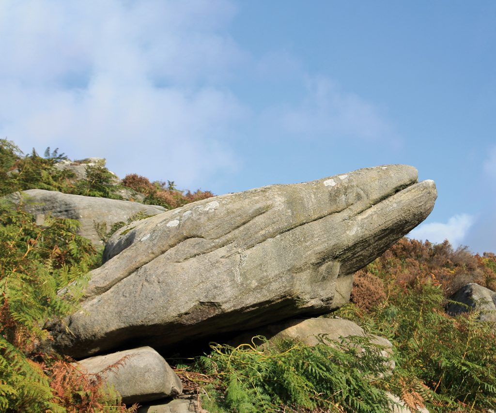
There are many enigmatic remains throughout the Peak District; stone circles, cairns and burial mounds were left by people who did not tell us who they were. Carl Wark the focal point of this walk is one such relic, but we have no way of telling if it was Iron Age or post-Roman, but it tells us that the people who used it had to protect themselves from attack by unfriendly others. When gentlemen took their ease by squinting along the barrel of an expensive shot gun aimed at some innocent moorland grouse, or semi-wild deer, chances are that many of them would have used nearby Longshaw Lodge for their accommodation. During the Great War, the lodge was used as a convalescence hospital for wounded Canadian Soldiers; there is a photograph of a group of them in the snow below the house; it stands beside the path in front of the lodge. With the decline of moorland shooting for so-called pleasure, the moors over which the hunters stalked has been handed over to the National Trust where anyone can wander freely along footpaths crossing the unspoilt moors and wild oak woods covering the valley sides of the lower Burbage River, all the way down to Grindleford. This walk starting from Longshaw joins a roadside path beside the aptly named Toad’s Mouth rock, before wandering out on to Hathersage Moor. At its centre the well-preserved prehistoric fort of Carl Wark sits enigmatically below the wild rocks of Higger Tor. Despite its condition, little is known about the fort’s history, remaining as a potential site for some future teams of archaeologists to work on. A path climbs directly across the moor to reach the massive stone defending walls of Carl Wark fort, by one of its two entrances. At this point the walls make an inward curve, creating overhangs from which defenders using crude bows and arrows could fire down on attackers trapped in the narrow gaps rising to the dual entrances. Today’s visitors can explore the site in total safety, while searching for the enigmatic rocking stone hidden amongst the remains of long abandoned hut circles. The fort is well-sited, at the centre of a nearby series of tracks leading the eye along a path climbing to the summit rocks of Higger Tor, the potential route of an extension to the walk. Our route turns immediately right at the foot of the fort’s rear walls. Here it follows an ancient pack horse track, down to a stone clapper bridge across one of Burbage Brook’s tributaries. On the far side of the bridge, the path climbs steadily uphill to join a path, part of Sheffield Country Walk, one of the long distance routes in this part of the Peak District. A right turn follows this path, later passing an abandoned large stone water trough. Unfortunately it was cracked by an ill-judged final chisel. From the path end beyond the ruined trough, another path starting beside the stream a little way before the Toad’s Mouth bend in the main road, to your right joins the brook which is then followed, past a small weir to a narrow footbridge. Crossing this, the way is gently uphill, past a small lake and then onwards to the lodge where refreshments are on sale. For something stronger there is always the Fox house Inn nearby where Jane Eyre descended from her coach. 00
Walk Derbyshire – Osmaston Park

The A52 Derby to Ashbourne road passes through some of the gentlest rural countryside in Derbyshire. Tiny villages little changed in centuries sit around junctions of minor roads that wander pleasantly between both ploughed fields and pasture. This walk skirts three of them, one barely bigger than a hamlet; starting at Osmaston, the largest, it wanders through Osmaston Park and on to Shirley. Field paths and farm tracks then take us by way of Shirley Mill and into the outskirts of Wyaston. Here a right turn takes the walk back into Osmaston Park, entering the village by way of its delightful green. It is complete with a duck pond and seats to rest and admire the scenery. Osmaston where the walk begins and ends was the home village to Osmaston Park, whose estate employees’ thatched cottages are now much sought after properties. The village church appears Victorian, rebuilt by the architect H I Stephens of Derby in 1845, but from the size of the venerable yews in its churchyard and the mediaeval font, it is obviously built on ancient foundations. While the parkland is magnificent, the 19th century Osmaston Manor is no more, abandoned apart from estate houses and the odd tower peeping over the surrounding trees as seen on the latter stages of the walk. Shirley, like Wyaston is only entered by a short but worthwhile extension to the walk as it passes so close: this village easily dates from the 14th century, but there are even older Norman stones slotted around the church doorway. The remains of a much damaged Saxon cross in the churchyard and a massive yew that was once badly damaged in a gale give some hint of its age. Further on is Wyaston that nestles in a green hollow a quarter of a mile off route, sharing its pub with neighbouring Edlaston, another village with an ancient yew in its churchyard. The Walk From the car park beside the village hall, turn right and walk down the street, past several thatched cottages and attractive brick-built old houses and their gardens. Bear left around the pond to follow a wide bridleway to the left of the park gates. This track is signposted to Shirley and is arrow-straight almost all the way. Walk on between fields and downhill through mature woodland. Go straight on at a crossing, continuing downhill to a causeway between two mill ponds. Go past a substantial one time water-powered saw mill on your right and re-enter the forest. Walk uphill and out of the tree cover, keeping the forest boundary on your right. Go past what appears to be kennels for the local hunt. The water mill was recently renovated and converted into a house. Parts of two long distance walks are used on this walk; the section between Osmaston and Shirley is along Bonnie Prince Charlie Walk, supposedly following his ill-fated route between Ashbourne and Derby. The other is from Shirley along part of the Centenary Way, a walk that wanders pleasantly across the fields of south-central Derbyshire. A surfaced lane continues along the route out of Osmaston Park. Where it meets the lane into Shirley, look out for a flight of wooden steps on the right. Climb these and follow a waymarked path, past a private garden and alongside hedgerows, then across fields. An extension into the compact village of Shirley is worthwhile if time allows. The village sits tightly around a staggered cross roads together with its venerable church where its broken cross is worth seeking out, or maybe the handy pub. This part of the walk is along a short section of the Centenary Way. Follow it slightly downhill towards the mature woodland of Shirley Park. Bear left in front of the woodland boundary, on to a farm track (muddy when wet), following it as far as a minor road. Turn right at the road and go between a farm and Shirley Mill now converted into a private house. Beyond the mill house look out for a finger post pointing the way through a gate and into fields. Walk past the mill pond and then begin to bear left, uphill on a pathless route through meadowland. At the top of the rise, climb a stile and go forwards to the right of farm buildings. Follow the farm lane around a sharp bend and then continue towards woodland marked by a cottage and a handful of caravans. Continue to follow the lane along the edge of the wood. Go past the drive to the first of two farms. Where the lane begins to go left at the second farm, climb over a stile on the right and into a field. Cross this and then over another stile. Follow the path through a wheat field. When the growing crop ends and overgrown grass begins, drop down alongside some trees to the road, reaching it through a gap in a broken wall. Turn right downhill along the road, going past the attractively yellow painted hollow square of Charity Farm to climb the hill opposite. At the top of the rise and unless diverting to Wyaston (return to this point if so doing), turn right and go down a bridle track and then out into fields gradually leading towards Osmaston parkland. With the rather eerie sight of the remnant towers of Osmaston Manor peeping above treetops on your right, go forwards along the track, past a couple of estate houses and the village cricket field to your left. Reaching a ‘T’ junction, turn left along the drive and go through two substantial gate posts, the remnants of the manor’s one time splendour. Walk past the village pond and go back into Osmaston village. Seats around the pond are just made to rest weary limbs and have the remaining drink left in the thermos. A rockery gone wild is in the middle of the pond and pretty thatched cottages make a perfect background. USEFUL INFORMATION: 6 miles (8.8km) of